
What is a Phase I?
Phase I is a historical research of a property.
Phase II is environmental testing of a property.
Phase III is remediation of a problem identified in a Phase I or a Phase II.

Phase I Environmental Site Assessment (ESA)
A Phase I property site assessment is a due diligence procedure that both buyers and sellers of commercial and industrial real estate perform to identify past and present environmental liabilities. A Phase I can prevent future litigation over a real estate transaction by openly disclosing environmental issues to both purchasers and owners of commercial real estate.
A Phase I ESA is meant to identify the potential for contamination of a site by hazardous or toxic materials and to identify  other possible environmental constraints on the site. It is not meant to be a detailed, comprehensive investigation based on quantitative or qualitative analytical data.
No environmental sampling and analysis will be performed under the Phase I scope of work. The form and content of an ESA I will follow the form and content as outlined in ASTM standard E 1527-21. The results of the Phase I ESA will be used to determine whether or not further study (such as a Phase II ESA) is warranted, based on the background information gathered and the results of the site inspection. To obtain and develop the information required for the Phase I ESA of a property in a timely and efficient manner, the following scope of work is typically performed subject to minor additions and deletions, as indicated by the availability, relevancy, and adequacy of the background information, and by the environmental consultant's best field judgment.
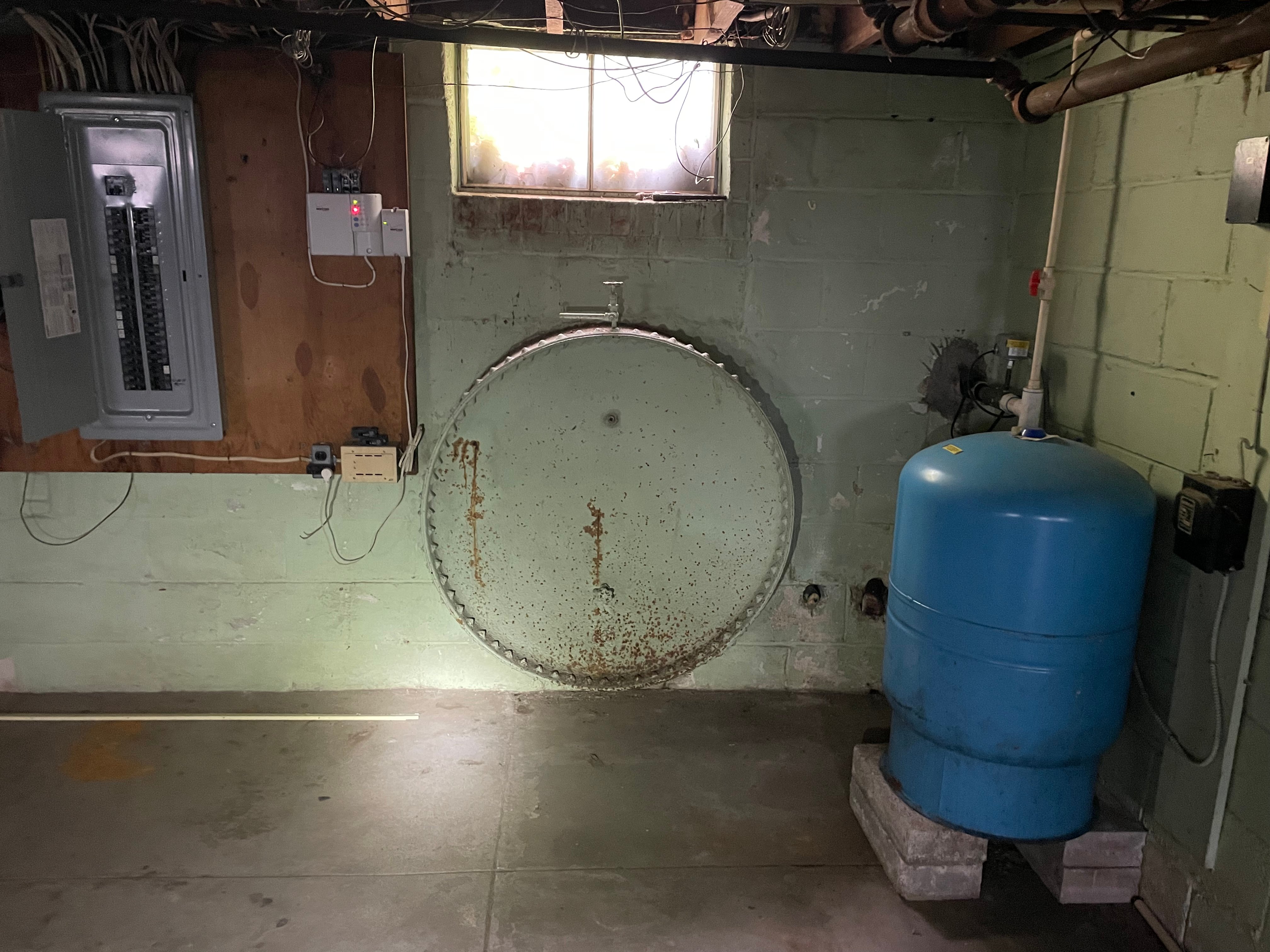
A Phase I includes extensive data research and historical record review AND a walking inspection of the property inconjunct ion with owner interview. Riveted steel cylinder in basement wall would be flagged as a potential Recognized Environmental Condition (REC). This is a RC because owner doesn't know what it is or was used for.
Task 1 - Off Site Review
- Identify the city, county and state where the site is located.
- Obtain and review current Federal and State databases of suspected and confirmed contaminated sites within the zip code of the site, or within a minimum of one (1) mile, including the following:
- NPL [Superfund], FINDS [EPA's Facility Index System], CERCLIS, RCRA, Open Dump Site listings, ERNS [Emergency Response Notification System], and the State Priority List, UST Facility Information, and Solid Waste Facility Information listings. State and local agencies will be contacted as necessary to determine if environmental monitoring or enforcement activities, investigations or claims have occurred on or near the site, and if industrial or waste water discharges to surface waters have occurred near the site.
- Indicate other agencies contacted, the name of the person contacted, and the information obtained.
- State the name and address of any listed facility found to be within one mile of the site. Based on the search, indicate the distance and direction from the site to these facilities.
Task 2 - Past Uses of the Site and Surrounding Land phase 1 environmental
 Review title information of the property (provided at Client's expense), and Sanborn Maps, if available, to obtain information on past uses of the property possibly pertaining to the storage, treatment or disposal of hazardous substances.
- Interview the current owners, employees, neighbors, government officials etc., regarding present and previous uses of the property and surrounding area. Indicate the name of the contact and information obtained.
- Examine readily-available historical aerial photographs and/or maps for indications of historical uses of the property, and for any evidence of potential on-site contamination, such as dumping or land filling.
- Investigate whether the site or surrounding land within a one (1) mile radius of the site is being or has been used for any of the following purposes:
- Agricultural (may be indicative of pesticide or herbicide used).
- Landfill.
- Tank/drum/equipment storage.
- Industrial/manufacturing facility (type).
- Oil/gas exploration.
- Chemical/petroleum or waste storage/processing/ injection wells
- Military installations.
- Fill areas.
- Quarries/sand and gravel extraction.
- Investigate whether there are or have been any storage tanks on the site and, where possible, what was stored in them. If possible, determine the age and the capacity of the tanks and whether a suspected release from the tanks has been reported. Determine if any existing tanks are in compliance with applicable tank laws and regulations.
Task 3 - Present and Proposed Use of Property/Surrounding Land
- Provide a Site Location Map of the area using a USGS Quadrangle Map with the site clearly identified
- Identify any land within one (1) mile of the site that is indicated or proposed as a permitted landfill, hazardous waste, or solid waste facility. If so, determine potential for environmental impact on the site.
- Determine if there is evidence that water wells, in use or abandoned, exist on the property. Indicate if they are the primary source of drinking water. Specify the present and proposed method of supplying drinking water.
- Determine the present or proposed method of sewage disposal, whether public or private. Determine if a septic system, abandoned or in use, exists on the site.
- Provide a preliminary hydro geological characterization of the site by reviewing soil survey maps, geological maps, topographical maps, flood plain maps and data, and any other pertinent data available for the property and it's vicinity.
Task 4 - Walking Inspection of Property
- A qualified Environmental Professional will conduct a walking inspection of the property in order to determine whether any of the following were discovered:
- Discolored or disturbed soil areas
- Areas of sparse, sick or dead vegetation.
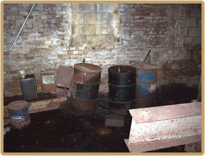
- Drums or storage tanks (note type).
- Discolored or polluted water; unusual or noxious odors.
- Groundwater monitoring wells.
- Floor drains.
- Roads with no apparent outlet or purpose.
- PCB containing transformers within structures or on power poles and lighting ballasts in older buildings. Other potential PCB containing material, such as soil near current or former railroad tracks.
- Maintenance practices and hazardous materials handling procedures.
- Any storage of significant quantities of potentially hazardous chemicals, including herbicides and/or pesticides.
- Potential use of lead based paint.
- Potential wetlands and flood plains.
- Provide documenting photographs.
Task 5 - Final Report
- Review the data developed from the field reconnaissance, agency contacts, and records for technical accuracy and corroboration. Analyze and assemble the data into a final report stating conclusions and recommendations either that no further study of the site be undertaken or that a Phase II Environmental Site Assessment be initiated.
- Determine whether there are any unique environmental factors, observations, or aspects of the site history which would justify further investigations.